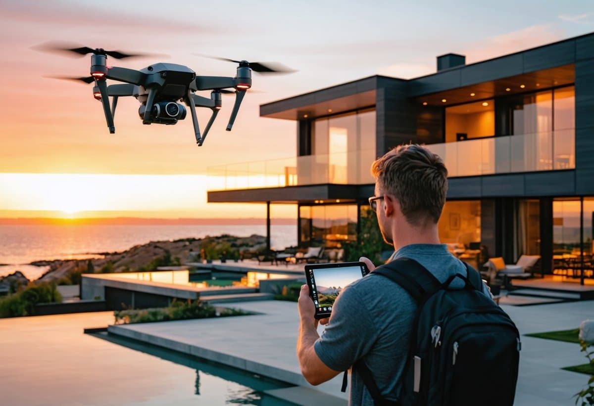
Picture this: You're standing in the driveway of a $5 million estate, your drone ascending into the golden hour sky, capturing sweeping aerial shots that will make this property irresistible to luxury buyers. Your client—a high-end real estate agent—will pay you $500 for this hour of work. Welcome to the explosive world of drone real estate photography in 2025, where updated FAA regulations, cutting-edge technology, and an insatiable luxury market have converged to create one of photography's most lucrative niches.
The numbers tell a compelling story: the drone services market is projected to reach $63.6 billion by 2025, with real estate photography commanding the highest per-hour rates in the industry. But here's the catch—new FAA rules implemented in 2024 and refined throughout 2025 have transformed the regulatory landscape, creating both opportunities and challenges for photographers ready to take their business skyward. Whether you're a seasoned photographer looking to diversify your income streams or a drone enthusiast ready to monetize your passion, this comprehensive guide will equip you with everything you need to capitalize on this booming market.
The 2025 Drone Real Estate Photography Gold Rush
The real estate photography landscape has undergone a seismic shift. What was once a nice-to-have luxury feature has become an absolute necessity in property marketing. According to the National Association of Realtors, listings with aerial photography sell 68% faster than those without, and properties marketed with drone footage command an average of 9% higher selling prices.
This isn't just about luxury estates anymore. Mid-range properties, commercial real estate, land parcels, and even rental properties are increasingly demanding aerial perspectives. The democratization of drone technology combined with sophisticated editing software has made professional-quality aerial imagery accessible—but only to those who understand both the technical and regulatory requirements.1
The earning potential is staggering. While traditional ground-level real estate photography might net you $150-$300 per property, adding drone services instantly elevates your value proposition. Top drone real estate photographers in major metropolitan areas regularly charge $400-$750 per shoot, with luxury property specialists commanding $1,000+ for comprehensive aerial and ground packages. The best part? Most drone shoots for residential properties take 30-60 minutes of flight time, making this one of the highest hourly rates in photography.
Understanding the 2025 FAA Drone Regulations: What Changed and Why It Matters
The regulatory environment for commercial drone operations has evolved significantly, and understanding these rules isn't optional—it's the foundation of your business legitimacy and legal protection. The Federal Aviation Administration (FAA) has implemented several critical updates that directly impact real estate photographers.
The Part 107 Remote Pilot Certificate: Your Essential License
First and foremost, commercial drone operation requires an FAA Part 107 Remote Pilot Certificate. This isn't negotiable—flying commercially without this certification can result in civil penalties up to $32,666 per violation. The good news? The certification process has been streamlined in 2025, with more testing centers and online study resources than ever before.
To obtain your Part 107 certificate, you must be at least 16 years old, pass an aeronautical knowledge test at an FAA-approved testing center, and complete a TSA background check. The test covers airspace classification, weather, drone loading and performance, emergency procedures, and FAA regulations. Most photographers report spending 15-20 hours studying before passing the exam, which costs $175.
Key 2025 Regulatory Updates
The 2025 regulatory framework introduced several significant changes that real estate photographers must navigate:
Remote ID Requirements: As of 2024, all drones operating commercially must broadcast Remote ID information, essentially creating a digital license plate for your aircraft. This means you'll need either a drone with built-in Remote ID capability or an external Remote ID broadcast module. Most drones manufactured after 2023 include this feature, but if you're using older equipment, budget $100-$300 for a compliant module.2
Operations Over People: The 2025 rules have clarified and expanded provisions for flying over people, which is particularly relevant for real estate photography in populated areas. Category 1 operations (drones under 0.55 pounds with no exposed rotating parts) can fly over people without restrictions. Category 2 and 3 operations require specific drone certifications and, in some cases, additional pilot authorizations. For real estate work, you'll typically want Category 2 certified drones, which allow limited operations over people.
Night Operations: Previously requiring a waiver, night operations are now permitted under Part 107 with anti-collision lighting visible for three statute miles and completion of updated training. This is a game-changer for real estate photographers, as twilight and night shots have become increasingly popular for showcasing exterior lighting and creating dramatic property presentations.
Expanded LAANC System: The Low Altitude Authorization and Notification Capability (LAANC) system has been expanded to cover virtually all controlled airspace in the United States. This automated system provides near-instant airspace authorizations for flights in controlled airspace, eliminating the previous weeks-long waiver process. For real estate photographers working in urban and suburban areas, LAANC is essential—many properties sit within controlled airspace around airports.
Essential Equipment: Building Your Drone Real Estate Photography Kit
Your equipment choices will directly impact both your image quality and your operational efficiency. While it's tempting to start with budget options, investing in professional-grade equipment pays dividends in image quality, reliability, and client confidence.
Best Drones for Real Estate Photography in 2025
DJI Mavic 3 Pro ($2,199-$4,799): The industry standard for professional real estate photography. Its Hasselblad camera system delivers exceptional image quality with a 20MP sensor and adjustable aperture. The three-camera system (including medium telephoto and telephoto lenses) provides unprecedented flexibility for capturing properties from multiple perspectives. Flight time of 43 minutes means you can shoot multiple properties without battery changes.
DJI Air 3 ($1,099): The best value proposition for photographers starting in drone real estate work. Dual cameras (wide-angle and 3x medium telephoto) provide professional versatility at a mid-range price point. The 46-minute flight time actually exceeds the Mavic 3 Pro, though image quality and low-light performance don't quite match the flagship model.
Autel Robotics EVO II Pro ($1,795): An excellent alternative to DJI with a 1-inch sensor capable of 6K video and 20MP stills. Particularly attractive for photographers concerned about data security, as Autel is a US-based company. The 40-minute flight time and omnidirectional obstacle avoidance make it reliable for complex property shoots.
Regardless of which drone you choose, ensure it meets Remote ID requirements and is Category 2 certified for operations over people. Most major manufacturers now include these certifications standard, but always verify before purchasing.
Critical Accessories and Backup Equipment
Professional drone operations require more than just the aircraft. Your complete kit should include:
Battery Arsenal: Never arrive at a shoot with fewer than four batteries. Professional real estate shoots often require 2-3 batteries minimum, and you need backup capacity for unexpected reshoots or extended sessions. Budget $150-$200 per battery for professional drones. Consider a charging hub that can charge multiple batteries simultaneously—this alone can save hours between shoots.
ND Filter Set: Neutral density filters are essential for achieving proper exposure and cinematic motion blur in video work. A quality variable ND filter or a set of ND8, ND16, and ND32 filters will cost $100-$300 but dramatically improves image quality, particularly in bright midday conditions.3
Tablet or Large-Screen Controller: While most drones come with smartphone compatibility, a dedicated tablet (iPad Mini is popular) provides a larger, brighter screen for composition and exposure verification. In bright outdoor conditions, this can be the difference between nailing the shot and discovering exposure problems back at your computer.
Landing Pad: A simple $30 investment that protects your drone from dust, grass, and debris during takeoff and landing. It also provides a visual reference point and professional appearance for clients watching the shoot.
For photographers serious about protecting their investment, consider reading our guide on photography gear protection, which covers insurance, cases, and maintenance strategies applicable to drone equipment.
Mastering the Technical Skills: From Hobbyist to Professional
Flying a drone is relatively easy—flying one professionally while capturing compelling real estate imagery requires developed skill and intentional practice. The technical gap between amateur drone footage and professional real estate photography is immediately apparent to clients, and mastering these skills is what justifies premium pricing.
Essential Flight Techniques for Real Estate
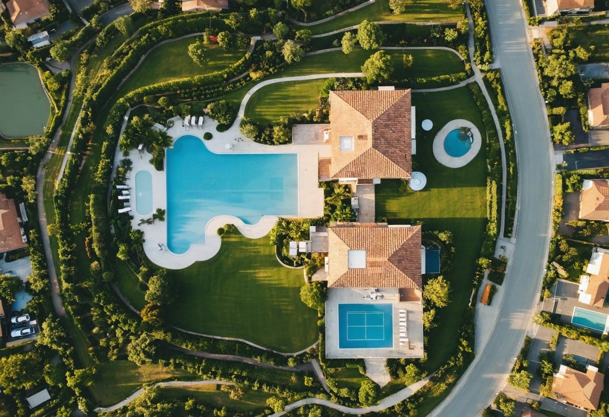
The Hero Shot: Every real estate property needs a signature aerial image that captures the entire property in context. This typically involves positioning the drone at 100-150 feet altitude, angled downward at approximately 30-45 degrees to show both the property's facade and its relationship to the surrounding neighborhood. Timing is crucial—golden hour light (the hour after sunrise or before sunset) adds warmth and dimension that midday light simply cannot provide.
Smooth Cinematic Movements: Jerky, rapid movements scream amateur. Professional real estate drone footage features slow, deliberate camera movements that reveal the property gradually. Master these fundamental movements: the reveal (flying backward while ascending), the orbit (circling the property at constant altitude and distance), the flyover (smooth forward flight over the property), and the approach (flying toward the property while descending slightly). Each movement should be executed at 2-4 mph maximum speed.
Composition for Real Estate: Apply traditional photographic composition principles from an aerial perspective. The rule of thirds remains relevant—position the property at intersection points rather than dead center. Include contextual elements that add value: nearby parks, water features, proximity to downtown areas, or expansive land. For luxury properties, emphasize unique features like pools, tennis courts, or architectural details visible from above.
Understanding composition principles from other photography disciplines can enhance your aerial work. Our article on landscape photography covers composition techniques that translate beautifully to aerial real estate imagery.
Camera Settings and Exposure Management
Proper exposure is critical in real estate photography, where both shadow detail and highlight preservation matter. Shoot in RAW format exclusively—the additional editing latitude is essential for professional results. For still photography, use aperture priority mode (if available) or manual mode, targeting f/4-f/5.6 for optimal sharpness while maintaining adequate depth of field.
ISO should remain as low as possible—typically ISO 100-200 for daylight shoots. Modern drones handle higher ISOs reasonably well, but image quality degrades noticeably above ISO 800. If you need faster shutter speeds in challenging light, it's better to slightly underexpose and lift shadows in post-processing than to introduce unnecessary noise with high ISO.
For video work, the 180-degree shutter rule applies: your shutter speed should be double your frame rate. Shooting at 30fps? Use 1/60 shutter speed. This creates natural motion blur and cinematic feel. This is where ND filters become essential—they allow you to maintain this shutter speed even in bright conditions.
Bracket your exposures for challenging scenes. Most professional drones support automatic exposure bracketing (AEB), capturing 3-5 images at different exposures that can be blended in post-processing for optimal dynamic range. This technique is particularly valuable for properties with bright skies and shadowed facades.
Building Your Real Estate Photography Business: From First Client to Full Schedule
Technical skills and equipment are necessary but insufficient for business success. Building a thriving drone real estate photography business requires strategic marketing, professional positioning, and systematic client acquisition.
Pricing Your Services for Profitability
Pricing is where many drone photographers leave money on the table. Your pricing should reflect not just your time on-site, but also travel, equipment costs, insurance, licensing, post-processing, and business overhead. Here's a realistic pricing framework for 2025:
Residential Properties: $250-$400 for standard packages including 15-20 edited aerial images and 1-2 minutes of edited video. Luxury properties ($1M+) should command $500-$750 for comprehensive packages with 25-30 images, extended video, and potentially twilight aerials.
Commercial Properties: $500-$1,500 depending on property size and complexity. Large commercial properties, industrial facilities, and development projects often require multiple flights, extensive coverage, and specialized deliverables. Price accordingly.
Land and Acreage: $300-$800 based on acreage and access challenges. Large land parcels may require multiple battery changes and extended flight time to capture adequately. Consider per-acre pricing for properties over 50 acres.
Add-On Services: Virtual tours ($200-$400), twilight photography ($150-$300 additional), 360-degree panoramas ($100-$200), and rush delivery ($100-$200) all provide opportunities to increase average transaction value.4
Never compete on price alone. Positioning yourself as a premium service provider with superior results, faster turnaround, and professional reliability will attract better clients who value quality over cost savings.
Marketing Strategies That Actually Work
Real estate agents are your primary clients, and they're constantly seeking photographers who can make their listings stand out. Your marketing should focus on demonstrating tangible value: faster sales, higher prices, and more buyer interest.
Portfolio Development: Before approaching paying clients, build a portfolio of 15-20 exceptional examples. Offer free or deeply discounted shoots to 3-5 real estate agents in exchange for portfolio rights and testimonials. Target agents who list properties in your desired price range and style.
Direct Outreach: Real estate agents respond to direct, personalized outreach. Identify top-producing agents in your area using public MLS data or platforms like Zillow. Send personalized emails highlighting specific listings where aerial photography would have enhanced the marketing. Include 2-3 portfolio examples and a specific call-to-action for a discounted introductory shoot.
Social Media Presence: Instagram and Facebook are essential for real estate photography marketing. Post your best work consistently (3-5 times weekly), use location tags and real estate hashtags, and engage with local real estate professionals. Before-and-after comparisons showing how aerial photography transforms property marketing perform particularly well.
For photographers looking to build their visual marketing presence, our guide on photography and marketing provides strategies for leveraging your visual content to attract clients.
Networking and Partnerships: Attend local real estate association meetings, broker open houses, and industry events. Partner with ground-level real estate photographers to offer comprehensive packages. Many established real estate photographers lack drone capabilities and welcome referral partnerships or subcontracting arrangements.
Post-Processing Workflow: From Raw Files to Stunning Deliverables
The images captured by your drone are merely raw material. Professional post-processing transforms good aerial shots into compelling marketing tools that sell properties. Your editing workflow should be efficient, consistent, and replicable across multiple shoots.
Essential Editing Software and Techniques
Adobe Lightroom: The foundation of most professional workflows. Lightroom excels at batch processing, allowing you to apply consistent adjustments across multiple images. Develop custom presets for different lighting conditions and property types. Key adjustments for real estate aerials include: clarity boost (15-25), vibrance increase (10-20), slight highlight reduction, shadow lifting, and perspective correction.
Adobe Photoshop: For advanced retouching and compositing. Essential techniques include sky replacement (when necessary), object removal (cars, equipment, debris), and perspective correction for architectural accuracy. The Content-Aware Fill tool is invaluable for removing unwanted elements while maintaining natural backgrounds.
Specialized Tools: DJI Terra or Pix4D for creating 3D models and orthomosaic maps from aerial imagery—increasingly valuable for land sales and development projects. Video editing software like Adobe Premiere Pro or Final Cut Pro for creating property tour videos with music, titles, and smooth transitions.
The Real Estate Editing Aesthetic
Real estate photography has a distinct aesthetic that differs from artistic photography. The goal is accurate, attractive representation that makes properties appealing without misrepresentation. Key characteristics include:
Color Accuracy: Grass should be naturally green (not neon), skies should be blue but believable, and architectural materials should appear true to life. Over-saturation is a common amateur mistake that undermines professional credibility.
Exposure Balance: Both highlights and shadows should retain detail. HDR techniques (merging multiple exposures) are standard practice, but the result should appear natural rather than obviously processed. Aim for bright, airy images with good contrast but without blown highlights or blocked shadows.
Straight Horizons: Nothing screams unprofessional like tilted horizons. Use Lightroom's auto-level feature or manually straighten every image. For architectural shots, ensure vertical lines are truly vertical using perspective correction tools.
Clean Backgrounds: Remove distracting elements when possible and practical: trash bins, parked cars in awkward positions, construction equipment. However, never remove permanent structures or materially alter the property representation—this crosses ethical lines and can create legal liability.
Develop a consistent editing style that becomes your signature while remaining within real estate aesthetic norms. Clients hire you partly for your distinctive look, but that look must serve the goal of selling properties effectively.
Common Mistakes That Cost You Clients and How to Avoid Them
The difference between struggling drone photographers and those commanding premium rates often comes down to avoiding preventable mistakes that undermine professional credibility.
Technical Mistakes
Inconsistent Focus: While most modern drones have excellent autofocus, infinity focus issues occasionally occur, resulting in soft images. Always review images at 100% zoom on your tablet or controller screen before leaving the location. Reshooting is easier than explaining unusable images to clients.
Poor Timing and Lighting: Shooting at noon with harsh overhead light is the fastest way to produce flat, unappealing images. Schedule shoots for golden hour whenever possible. If midday shooting is unavoidable due to client schedules, use this time for property details and angles where harsh light matters less, saving hero shots for better light.
Inadequate Coverage: Shooting too few images is a rookie mistake. Professional shoots should yield 40-60 raw images from which you'll select and edit 15-25 finals. This ensures you have multiple options for every angle and won't discover gaps in coverage after leaving the location.
Ignoring Weather Conditions: Wind is the enemy of stable, sharp aerial photography. Most consumer and prosumer drones handle 15-20 mph winds reasonably well, but image quality suffers and flight safety becomes questionable. Develop a policy for weather-related rescheduling and communicate it clearly to clients upfront.
Business Mistakes
Operating Without Proper Insurance: General liability insurance for drone operations costs $500-$1,200 annually and is non-negotiable. Many professional clients won't hire you without proof of insurance, and a single accident could bankrupt your business without coverage. Look for policies specifically designed for commercial drone operations with minimum $1 million coverage.5
Unclear Deliverables and Timelines: Establish clear expectations before every shoot: how many images will be delivered, in what format, and within what timeframe. Most professional real estate photographers deliver within 24-48 hours—this quick turnaround is often a key differentiator. Create a standard contract or service agreement that specifies all terms, usage rights, and payment conditions.
Underpricing to Win Business: Competing primarily on price attracts price-sensitive clients who are often the most difficult to satisfy and least likely to become repeat customers. Position yourself as a premium service provider and let budget photographers compete for bottom-tier clients. Your ideal clients value quality and reliability over cost savings.
Neglecting Client Communication: Real estate agents work in a fast-paced environment with tight deadlines. Respond to inquiries within 2-4 hours during business hours, confirm shoots 24 hours in advance, and provide delivery updates proactively. Professional, responsive communication often matters as much as image quality for client retention.
Advanced Techniques: Standing Out in a Competitive Market
Once you've mastered the fundamentals, advanced techniques allow you to command premium pricing and attract high-end clients who demand exceptional results.
Twilight and Night Aerial Photography
Twilight aerials—captured during the 20-30 minute window after sunset when the sky retains deep blue color while property lights glow warmly—have become the signature shot for luxury real estate. These images command premium pricing ($200-$400 additional) because they require precise timing, advanced technique, and often multiple visits to a property.
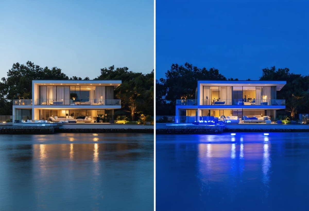
The key to successful twilight aerials is preparation. Scout the location during daylight to plan your shots and identify obstacles. Arrive 45 minutes before sunset to set up and capture some golden hour aerials. As sunset approaches, coordinate with the homeowner or agent to turn on all exterior and interior lights. The magic moment occurs about 15-25 minutes after sunset—shoot continuously during this window as light changes rapidly.
Camera settings for twilight require balancing ambient light with artificial lighting. Start with ISO 400-800, aperture f/2.8-4.0, and shutter speeds around 1/30-1/60 second. Bracket exposures heavily—you'll likely blend multiple exposures in post-processing to balance bright windows with darker exteriors and sky.
Much like the techniques used in night photography, twilight aerials require patience, planning, and understanding of how cameras capture light differently than human eyes perceive it.
360-Degree Panoramas and Virtual Tours
Aerial 360-degree panoramas provide immersive experiences that standard photos cannot match. Most professional drones include automated panorama modes that capture and stitch multiple images into seamless spherical panoramas. These can be embedded in property listings, allowing potential buyers to explore the property's surroundings interactively.
For maximum impact, capture 360 panoramas at multiple altitudes: one at 50-75 feet showing the immediate property and neighborhood context, and another at 200-300 feet (if regulations permit) showing broader area context. Process these using specialized software like PTGui or the drone manufacturer's app, then host on platforms like Kuula or Roundme for easy embedding in property websites.
Orthomosaic Mapping for Land and Development
For land sales, development projects, and commercial properties, orthomosaic maps—geometrically corrected aerial images that can be used as maps—provide tremendous value. These require specialized software (DJI Terra, Pix4D, or DroneDeploy) but allow you to offer services beyond standard photography.
Creating orthomosaics involves flying automated grid patterns over the property at consistent altitude while the drone captures overlapping images (typically 70-80% overlap). The software then processes hundreds of images into a single, accurate overhead view with measurable dimensions. This service can command $500-$2,000+ depending on acreage and deliverable requirements.
Safety, Risk Management, and Professional Standards
Professional drone operation requires unwavering commitment to safety. Beyond the obvious ethical imperative, your reputation and business viability depend on maintaining a perfect safety record.
Pre-Flight Planning and Risk Assessment
Every flight should begin with systematic planning. Use apps like AirMap, B4UFLY, or UAV Forecast to check airspace restrictions, temporary flight restrictions (TFRs), and weather conditions. Verify that you're not within restricted zones around airports, stadiums during events, or emergency operations.
Create a pre-flight checklist and use it religiously: verify battery levels (drone and controller), check propellers for damage, ensure firmware is updated, confirm GPS signal acquisition, verify compass calibration, and inspect the flight area for obstacles and hazards. This systematic approach takes 3-5 minutes but prevents the vast majority of preventable accidents.
Maintain visual line of sight at all times—it's not just an FAA requirement, it's essential for safe operation. While modern drones have excellent obstacle avoidance, these systems aren't foolproof. Birds, power lines, and unexpected obstacles require human judgment and reaction.
Privacy and Ethical Considerations
Real estate drone photography often involves flying over or near neighboring properties, raising legitimate privacy concerns. Develop and follow ethical guidelines that go beyond legal minimums. Avoid capturing images of neighboring properties' interior spaces through windows. Don't linger over adjacent properties longer than necessary to capture your client's property. If neighbors express concerns, take time to explain what you're doing and show them sample images.
Consider providing your contact information to immediate neighbors before shoots, particularly for luxury properties where privacy is a premium concern. This proactive approach prevents complaints and demonstrates professionalism.
Understanding the broader context of privacy in photography can inform your approach to drone work. Our article on legal and ethical considerations in street photography explores privacy principles that apply across photographic disciplines.
The Future of Drone Real Estate Photography: Trends and Opportunities
The drone real estate photography market continues evolving rapidly, with emerging technologies and changing consumer expectations creating new opportunities for forward-thinking photographers.
AI-Enhanced Editing and Automation
Artificial intelligence is transforming post-processing workflows. Tools like Adobe Sensei (integrated into Lightroom and Photoshop) and specialized platforms like Imagen AI can now handle routine editing tasks—sky enhancement, exposure balancing, color correction—with minimal human intervention. This automation allows photographers to handle higher volume while maintaining quality, directly impacting profitability.
However, AI can't replace human judgment about composition, storytelling, and property-specific marketing angles. The most successful photographers will leverage AI for efficiency while focusing human expertise on creative decisions that differentiate their work. For deeper exploration of AI's impact on photography, see our comprehensive analysis of AI photography.
FPV Drones and Cinematic Property Tours
First-person view (FPV) drones capable of flying through properties—entering through doorways, navigating rooms, and creating impossibly smooth single-take tours—represent the cutting edge of real estate videography. These dramatic tours command premium pricing ($1,500-$5,000 for luxury properties) but require specialized equipment and advanced piloting skills.
While FPV work requires significant additional investment in equipment and training, it represents a natural progression for established drone real estate photographers looking to differentiate their services and access ultra-luxury markets.
Expanded Regulatory Framework and Beyond Visual Line of Sight
The FAA continues developing regulations for Beyond Visual Line of Sight (BVLOS) operations, which could revolutionize how photographers cover large properties and land parcels. While currently requiring special waivers, BVLOS operations may become more accessible by 2026-2027, enabling single-operator coverage of properties that currently require multiple flights or even multiple days.
Stay informed about regulatory developments through the American Society of Media Photographers, which provides regular updates on drone regulations affecting professional photographers.
Taking Action: Your Roadmap to $500/Hour Drone Real Estate Photography
The opportunity in drone real estate photography is real, substantial, and accessible to photographers willing to invest in the right equipment, training, and business development. But opportunity alone doesn't build businesses—systematic action does.
Start by obtaining your Part 107 certification if you haven't already. This is your foundation—everything else builds on legal, certified operation. Invest in quality equipment that will serve you professionally for years rather than budget options you'll quickly outgrow. The difference between a $1,000 drone and a $2,000 drone is negligible compared to the difference in client perception and image quality.
Build your portfolio deliberately, targeting the property types and price ranges you want to specialize in. Five exceptional portfolio pieces in your target market segment are worth more than fifty mediocre images across all property types. Develop relationships with real estate professionals through consistent outreach, networking, and delivering exceptional results that make their jobs easier and their listings more successful.
Price your services based on the value you provide, not just your costs or competitors' rates. A real estate agent who sells a property faster and for $50,000 more because of your aerial photography doesn't care whether you charged $300 or $500—they care about results. Position yourself as the photographer who delivers those results.
Most importantly, commit to continuous improvement. Technology evolves, techniques advance, and client expectations rise. The photographers commanding $500+ per hour in 2025 are those who consistently invest in their skills, equipment, and business acumen. This is a marathon, not a sprint—but for those willing to run it, the rewards are substantial and sustainable.
The sky isn't the limit in drone real estate photography—it's just the beginning. Your next move determines whether you'll watch this opportunity from the ground or capture it from above.
- The drone real estate photography market has grown at a compound annual growth rate (CAGR) of 23.7% since 2020, significantly outpacing traditional real estate photography growth of 8.2% during the same period.
- Remote ID broadcasts the drone's location, altitude, velocity, and control station location in real-time, allowing the FAA and law enforcement to identify drones in flight. This requirement was phased in throughout 2023-2024 and is now fully enforced.
- ND filters work like sunglasses for your camera, reducing the amount of light entering the lens without affecting color. This allows you to use slower shutter speeds for video work, creating natural motion blur that makes footage appear smooth and cinematic rather than stuttery.
- Industry research shows that photographers who offer package options with clear add-on services earn 34% more per client than those offering single-price services, even when the base package price is identical.
- Standard homeowner's or renter's insurance policies explicitly exclude commercial drone operations. You need specialized UAV liability insurance that covers both property damage and privacy/personal injury claims.